New England Sailing Center (NESC)

New England Sailing Center

Celestial Navigation Endorsement

Celestial Navigation-260x221
  • Description:

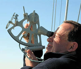
Celestial Navigation is a classroom theory and practice course to determine latitude and longitude at sea using a sextant and Nautical Almanac. This is a one day course with a noon sighting taken at Beavertail.

Please visit our course and certification information page for more information on pricing. Contact us to check course availability and to schedule your course.


Directions: Getting to Us

  • Prerequisites: None
  • Certification: ASA 117 Celestial Navigation Endorsement
  • Duration: 1 day classroom based course 9-5; noon siting will be taken at Beavertail
  • Curriculum:

Study materials: Latitude & Longitude from the Noon Sun by John Karl

  1. Describe the terms and theory of Basic Celestial Navigation. Using a traditional sextant and Nautical Almanac and without the use of a programmed calculator or computer
  2. Convert between standard time and zone time to GMT/UT in either direction.
  3. Calculate the zone time at a given longitude.
  4. Determine the times of sunrise, sunset and civil twilight for a vessel’s position.
  5. Describe and identify the parts, principals and operation of a traditional sextant.
  6. Determine altitudes of the Sun and Polaris by a traditional sextant.
  7. Obtain Latitude and Longitude at noon (LAN) by applying the sextant corrections for conversions of the raw sextant altitudes (hs) of the Sun to the true celestial altitudes (HO) of the Sun.
  8. Determine the vessel’s latitude and Estimated Position at morning and evening twilight by means of the altitude of Polaris.
  9. Plot latitudes and EPs on a chart.